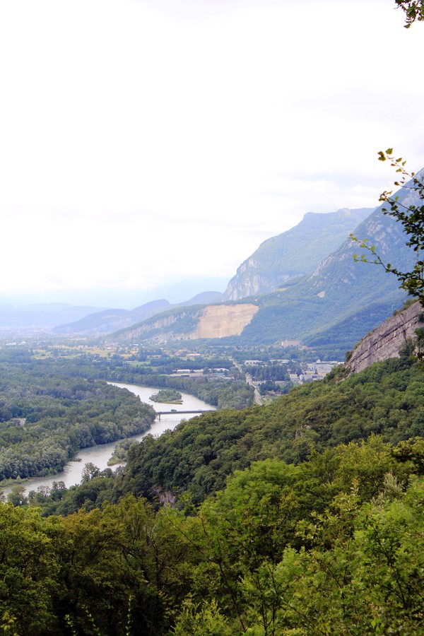
The Saint-Ours chapel and the Echaillon viewpoint
Of the 12 communes nestled at the foot of the Vercors, Veurey-Voroize is the most northerly. The walk proposed here leads to the Saint-Ours chapel, next to the Echaillon viewpoint.
-
The Saint-Ours chapel and the Echaillon viewpoint
Petit Port
38113 VEUREY-VOROIZE
Route
- Languages: Fr
Step by step
Departure is either from Veurey, or directly from Petit Port, 2 km after the village of Veurey. In both cases, follow the signs for Saint Ours. Above Petit Port, your soles soon tread the shiny slabs of a Roman road, some sections of which are quite well preserved. After 15 to 20 minutes of fairly steep climbing, at 355 m, turn left towards the chapel and the belvedere. The characteristic vegetation of hilly limestone slopes accompanies the hiker: mainly fragon, boxwood, holly and downy oak. After 30 minutes, at an altitude of 480 m, the path comes alongside the arrival station of an old cable car. From the early 20th century until the 1980s, it was used to transport wood, and later to supply the Saint Ours farm. After another 30-minute ascent, the landscape opens up as we reach the ridge, and there's a change of scenery! Perched on the northern edge of the Vercors massif, at an altitude of 620 m, the hiker overlooks the exit of the Cluse de Voreppe, discovering new horizons over the Isère valley, the Pays Voironnais and the Sud Grésivaudan. Today, it's hard to believe that the Roman road that can still be seen below was a compulsory passage on the Valence-Grenoble route, as the cyclical flooding of the Isère made the valley impassable. Allow 45 minutes for the descent. At the cable-car station, turn left to vary the route. Join the path leading up to Les Combes, at 355 m, to reach Petit Port in just a few minutes.
SEE AND KNOW:The famous Echaillon stone was shipped from Petit Port. It can be seen, for example, at the Natural History Museum (colonnades overlooking the Jardin des Plantes, as well as elements of the facade). From Roman times to the 17th century, limestone extracted from Echaillon was transported by river. In the 18th century, violent flooding washed out the access road, and the quarry did not resume regular activity until 1848. The quarries closed for good in 1939.
Rates
Free access.
Opening periods
All year round.
Equipments and characteristics
- Pets allowed
Access
Bus Line 20 Stop La Rive Veurey-Voroize
Bis bus Flexo 51 Stop Mairie Veurey-Voroize (only in the morning and evening)
- Latitude: 45.285674
- longitude: 5.611920
Environnement
- Close to a public transportation
Track characteristics
- Distance:
- 4 km
- Positive level difference:
- 460 m
- Daily duration:
- 2 h 30 min
- Level:
- Level green – easy
- Type:
- Round-trip
